
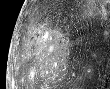
April 2025 Image:

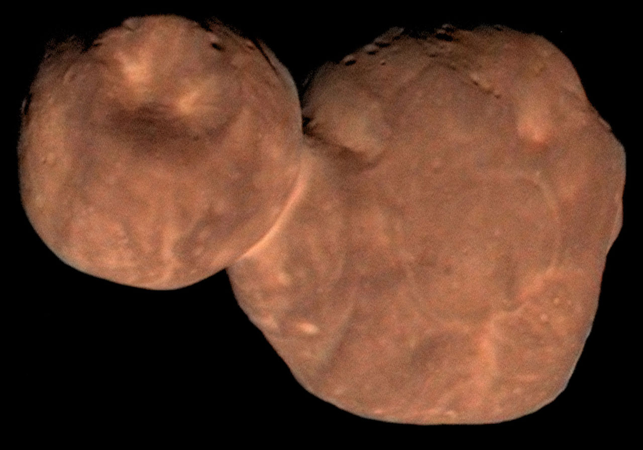
The image provided in this month’s quiz was a small portion (bottom right corner) of a much larger object, as shown above. This is asteroid Donaldjohanson, which NASA’s Lucy spacecraft encountered as it toured the main asteroid belt between Mars and Jupiter.
Here is a little more about the asteroid and Lucy’s mission from NASA:
Main belt asteroid 52246 Donaldjohanson is about 8 kilometers long and 3.5 kilometers across. On April 20, this sharp close-up of the asteroid was captured at a distance of about 1100 kilometers by the Lucy spacecraft’s long range camera during its second asteroid encounter. Named after American paleoanthropologist Donald Johanson, discoverer of the Lucy hominid fossil, the elongated asteroid was likely formed about 150 million years ago from a gentle collision of two smaller bodies creating its characteristic contact binary shape. Launched in October of 2021, the Lucy spacecraft will continue its travels through the main asteroid belt in 2025, but is on its way to explore Jupiter’s swarm of Trojan asteroids. Lucy is expected to encounter its first Trojan asteroid target, 3548 Eurybates, in August 2027.
February 11, 2025 Image:
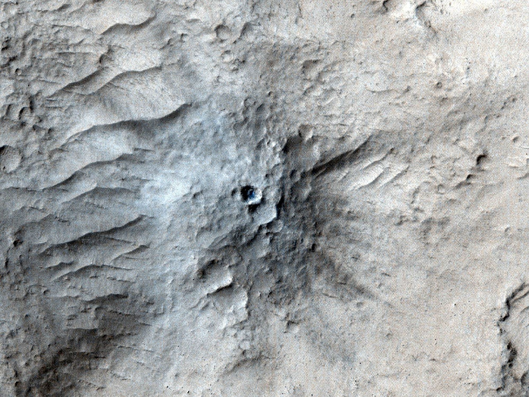
The image for this month’s quiz comes from NASA’s Mars Reconnaissance Orbiter using its High-Resolution Imaging Science Experiment (HiRISE) camera. It was taken on March 4, 2021 and shows an impact crater in Cerberus Fossae, which is a seismically active region of Mars.
Here is more about the impact crater from NASA:
Scientists matched the crater’s appearance on the surface with a quake detected by NASA’s InSight lander, which was about 1,000 miles (1,640 kilometers) away. The crater is estimated to be about 71 feet (21.5 meters) in diameter.
Most of the impacts detected by InSight, which was retired in 2022 after operating for more than four years, were thought to send their seismic signals through the Martian crust. But scientists concluded the energy from this impact traveled through the planet’s mantle, much deeper than expected, after studying the location of the impact crater and seismic signals linked to it. Because of this finding, models of the composition and structure of the inner planet will have to be reassessed.
This impact crater, along with others covered in a pair of papers published in Geophysical Research Letters in February 2025, was found with help from a machine learning algorithm developed at NASA’s Jet Propulsion Laboratory in Southern California. The algorithm searched through tens of thousands of images captured by MRO’s Context Camera in a matter of days, detecting 123 potential craters that may have occurred at the same time InSight was recording data. Traditional methods, in which human scientists carefully peer over images pixel by pixel, would have taken years of work to find these matches.
Human scientists still had to narrow down the pool of candidate craters to 49 that matched InSight’s quake data. After discovering this impact, scientists commanding MRO to take more detailed imagery with HiRISE.
August 26, 2024 Image:

The image for this month’s quiz comes from an archaeological site in Poland. The item in the archaeologist’s hand is a compass that may have belonged to the astronomer Nicolaus Copernicus. The device is also called a divider and was commonly used 500 years ago for measurements in cartography, geometry and astronomy.
The compass was found in the garden of Copernicus’s home in Frombork, the town where Copernicus lived for 30 years conducting his astronomical work.
The compass has been given to the Nicolaus Copernicus Museum, which is also located in Frombork.
July 21, 2024 Image:

The image for this month’s quiz was taken by NASA’s Juno spacecraft on May 12, 2024 during its 61st close flyby of Jupiter. This image captures the northern hemisphere of the planet. The swirls may have given it away. The full image below is more vibrant.
In describing on this image, NASA stated:
It provides a detailed view of chaotic clouds and cyclonic storms in an area known to scientists as a folded filamentary region. In these regions, the zonal jets that create the familiar banded patterns in Jupiter’s clouds break down, leading to turbulent patterns and cloud structures that rapidly evolve over the course of only a few days…At the time the raw image was taken, the Juno spacecraft was about 18,000 miles (29,000 kilometers) above Jupiter’s cloud tops, at a latitude of about 68 degrees north of the equator.

June 28, 2024 Image:
The image for this month’s quiz was taken by NASA’s Galileo spacecraft, which launch in October 1989 and orbited Jupiter and its moons until its demise in September 2003 when it crashed into Europa.
The image above (and a fuller view below) shows the surface of Jupiter’s moon Ganymede. NASA explains:
This natural color view of Ganymede was taken from the Galileo spacecraft during its first encounter with the satellite. The dark areas are the older, more heavily cratered regions and the light areas are younger, tectonically deformed regions. The brownish-gray color is due to mixtures of rocky materials and ice. Bright spots are geologically recent impact craters and their ejecta.
The finest details that can be discerned in this picture are about 8 miles (13.4 kilometers) across. The images which were combined for this color image were taken beginning at Universal Time 8:46:04 UT on June 26, 1996.

May 22, 2024 Image:

The image for this month’s quiz is the Martian moon Phobos as captured by NASA’s High Resolution Imaging Science Experiment (HiRISE) camera on the Mars Reconnaissance Orbiter. The crater above is at at the far right of the moon as it appears below and within the Stickney Crater, which is more apparent when you see the full moon. The small moon (17 x 14 x 11 miles in diameter) is expected to either crash into the surface of Mars or break up in space, creating one more ringed planet in our solar system.
Here is a little more information from NASA on the Phobos first image below:
The most prominent feature on Phobos is Stickney Crater, which is named for Chloe Angeline Stickney Hall, mathematician and wife of astronomer Asaph Hall. Asaph Hall discovered both the Red Planet’s moons in 1877.
Stickney crater is about 6-miles (9.7 kilometers) wide, and takes up about half the moon’s surface. NASA Mars Global Surveyor took images of the crater, and it appears to be filled with fine dust, with evidence of boulders sliding down its sloped surface.
Phobos and Deimos appear to be composed of C-type rock, similar to blackish carbonaceous chondrite asteroids. Observations by Mars Global Surveyor indicate that the surface of this small body has been pounded into powder by eons of meteoroid impacts, some of which started landslides that left dark trails marking the steep slopes of giant craters.
Measurements of the day and night sides of Phobos show such extreme temperature variations that the sunlit side of the moon rivals a pleasant winter day in Chicago, while only a few kilometers away, on the dark side of the moon, the climate is more harsh than a night in Antarctica. High temperatures for Phobos were measured at 25 degrees Fahrenheit (-4 degrees Celsius) and lows at -170 degrees Fahrenheit (-112 degrees Celsius). This intense heat loss is likely a result of the fine dust on Phobos’ surface, which is unable to retain heat.


April 28, 2024 Image:

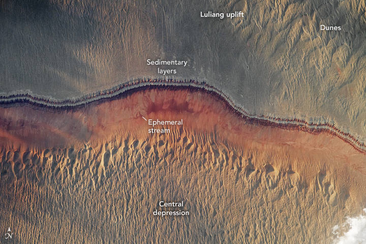
The image for this month’s quiz is from NASA’s Earth Observatory. The image was taken over China on June 1, 2023, and is titled “Evening Glow in the Junggar Basin, China.” This is one of 25 images shown in a NASA video to recognize the 25 years of service of service from the Earth Observatory, first launched on April 29, 1999.
The image is described by NASA in this way:
The reddish ribbon across the middle of this photo marks a change in local topography. Uplifted, older sedimentary layers to the north—part of the Luliang uplift—slope down toward a geographic depression to the south. Eroded rocks have drainage patterns that lead to an ephemeral stream at lower elevations. On both the top and bottom of the photo, long sand dunes oriented north-south overlay the bedrock. Beneath the surface, organic-rich rock layers preserve fossils and contain extensive coal, oil, and gas deposits.
March 31, 2024 Image:

The second image for this month (to make up for the lack of a quiz in February) is Canada’s Rio Tinto Alcan Montreal Planetarium.
Opened in 2013, the architecture was designed to connect the earth with the sky. The planetarium’s website notes:
So the building’s cones became metaphors for this relationship with the sky, sort of mega-telescopes housing the two star theatres at the heart of the project. To merge the experience of astronomy with that of nature, special attention was paid to the “naturalization” of the internal and external environments:
- The main entrance opens onto a walkway that straddles the courtyard, a small natural haven sheltering a grove of trees;
- Wood, a natural element par excellence was featured, bringing warmth and poetry to the structure while underlining the theme, as can be seen in the wooden slats so reminiscent of the rings of Saturn; [and]
- The green roof invites us to an unusual exploration from its three access points.
March 10, 2024 Image:

The image in this month’s quiz is an artist’s rendering of the asteroid Psyche. The full image is provided below.
NASA’s mission to visit the asteroid, launched last October, is to determine whether the asteroid’s exposed nickel-iron surface is the core of an early planet. The asteroid Psyche is located in the asteroid belt between Mars and Jupiter.
The scientific objectives of the mission include:
- Determine whether Psyche is a core, or if it is unmelted material;
- Determine the relative ages of regions of Psyche’s surface;
- Determine whether small metal bodies incorporate the same light elements as are expected in the Earth’s high-pressure core;
- Determine whether Psyche was formed under conditions more oxidizing or more reducing than Earth’s core; and
- Characterize Psyche’s topography.

January 22, 2024 Image:
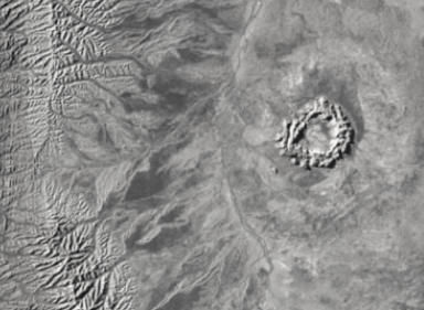
The image in this month’s quiz is a black and white version of a much larger image (shown below) taken by the International Space Station. It shows the Gosses Bluff impact crater west of Alice Springs, in Northern Territory, Australia. The crater is 2.7 miles in diameter and formed 142 million years ago. You can go here to learn more about this crater.

December 16, 2023 Image:

The image in this month’s quiz is a computer-generated three-dimensional perspective view of the surface of Venus using information from NASA’s Magellan spacecraft. This particular image shows the Gula Mons volcano.
The Magellan spacecraft arrived at Venus in 1990 with a mission to map the surface of the planet. It did so until 1994, when it was intentionally crashed into the planet’s surface to acquire even more data.
The key scientific results of this mission, as noted by NASA, include:
- Study of the Magellan high-resolution global images is providing evidence to understand the role of impacts, volcanism, and tectonism in the formation of Venusian surface structures.
- The surface of Venus is mostly covered by volcanic materials. Volcanic surface features, such as vast lava plains, fields of small lava domes, and large shield volcanoes are common.
- There are few impact craters on Venus, suggesting that the surface is, in general, geologically young – less than 800 million years old.
- The presence of lava channels over 6,000 kilometers long suggests river-like flows of extremely low-viscosity lava that probably erupted at a high rate.
- Large pancake-shaped volcanic domes suggest the presence of a type of lava produced by extensive evolution of crustal rocks.
- The typical signs of terrestrial plate tectonics – continental drift and basin floor spreading – are not in evidence on Venus. The planet’s tectonics is dominated by a system of global rift zones and numerous broad, low domical structures called coronae, produced by the upwelling and subsidence of magma from the mantle.
- Although Venus has a dense atmosphere, the surface reveals no evidence of substantial wind erosion, and only evidence of limited wind transport of dust and sand. This contrasts with Mars, where there is a thin atmosphere, but substantial evidence of wind erosion and transport of dust and sand.
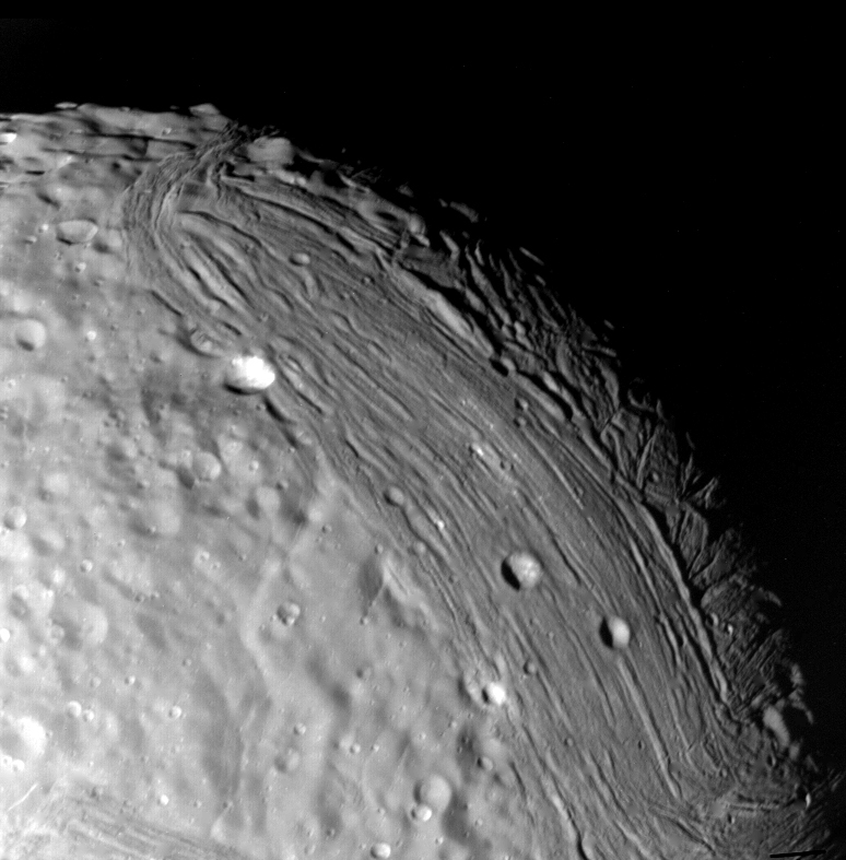
November 13, 2023 Image:

This image in this month’s quiz shows Saturn’s outermost moon, Iapetus, first discovered in 1671.
Here is more on the moon from NASA:
Iapetus has been called the yin and yang of the Saturn moons because its leading hemisphere has a reflectivity (or albedo) as dark as coal (albedo 0.03-0.05 with a slight reddish tinge) and its trailing hemisphere is much brighter at 0.5-0.6.
Saturn’s third largest moon, Iapetus has a mean radius of 457 miles (736 kilometers) and a density only 1.2 times that of liquid water. It has been suggested that Iapetus (like Rhea) is three quarters ice and one quarter rock.
Iapetus orbits at 2,213,000 miles (3,561,000 kilometers) from Saturn…However, despite the great distance, Saturn has tidally locked Iapetus. The moon always presents the same face toward Saturn. With its distant, inclined orbit, Iapetus is the only large moon from which there is a nice view of the rings of Saturn.

October 4, 2023 Image:

The mystery image in this week’s quiz is Pan, one of Saturn’s moons, taken by NASA’s Cassini spacecraft back in 2017. Yes, its form can best be described as ravioli-like. There was always talk of a Flying Spaghetti Monster somewhere out there. Now we know where it lives.
Here is more about the moon from NASA:
Pan, the innermost of Saturn’s known moons, orbits the planet from inside a gap in one of Saturn’s rings. It completes an orbit every 13.8 hours at an altitude of 83,000 miles (134,000 km). These two images from the Cassini spacecraft show how the spacecraft’s perspective changed as it passed within 15,300 miles (24,600 km) of Pan. This was the spacecraft’s closest encounter with Pan, improving the level of detail seen on the little moon from previous observations. The ridge around Pan’s equator is similar to Saturn’s moon Atlas, and gives the moon its distinctive dumpling shape. Pan was discovered by M.R Showalter in 1990 using images taken by the Voyager 2 spacecraft nine years earlier.

September 16, 2023 Image:
The image above from this week’s quiz was taken by the New Horizons spacecraft after its encounter with Pluto. It shows Object 2014 MU69, officially named Arrokoth, found in the Kuiper Belt.
Here is more about the discovery of this object from NASA:
More than 5 billion miles from Earth and 17 years into a mission that included the first close-up exploration of Pluto and the first encounter with a planetary building block in the Kuiper Belt, NASA’s New Horizons continues to shed light on the mysterious planets and smaller bodies of the outer solar system.
Launched in January 2006, the New Horizons spacecraft zoomed past Pluto and its moons in July 2015, before conducting the first reconnaissance of a Kuiper Belt object (KBO), Arrokoth, on New Year’s 2019. The data New Horizons gathered and beamed home during these historic encounters continues to yield new insights into the previously unexplored regions.
August 6, 2023 Image:

The image above from this week’s quiz shows a section on Jupiter’s moon Io, as seen by NASA’s Galileo Orbiter back in September 1996. The Galileo spacecraft was launched in October 1989.
Here is more on the image from NASA:
Io, the most volcanic body in the solar system is seen in the highest resolution obtained to date by NASA’s Galileo spacecraft. The smallest features that can be discerned are 2.5 kilometers in size. There are rugged mountains several kilometers high, layered materials forming plateaus, and many irregular depressions called volcanic calderas. Several of the dark, flow-like features correspond to hot spots, and may be active lava flows. There are no landforms resembling impact craters, as the volcanism covers the surface with new deposits much more rapidly than the flux of comets and asteroids can create large impact craters. The picture is centered on the side of Io that always faces away from Jupiter; north is to the top.

July 12, 2023 Image:

The image above is a view of Mercury’s north pole as seen by NASA’s (Mercury Surface, Space Environment, GEochemistry and Ranging) MESSENGER spacecraft. Its mission lasted from 2011 to 2015.
While Mercury has a surface temperature of 800 degrees Fahrenheit, an earlier story on the mission noted:
At Mercury’s north pole there are some deep craters. For example, the large crater Prokofiev is the deepest crater measured on Mercury so far. It’s over 110 kilometers (68 miles) across. Because the crater is deep, and the Sun never gets very high off the horizon at the pole, there are parts of the crater floor that are permanently in shadow; they literally are never illuminated by the Sun. Those spots can be very cold; well below the freezing point of water. There are actually quite a few spots like that at Mercury’s north pole.
June 9, 2023 Image:
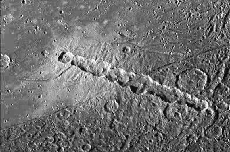
The image in this week’s quiz is a Enki Catena, a chain of 13 craters 162 kilometers in length on Jupiter’s moon Ganymede. In the Phys.org article, “Five Incredible Craters That Will Make You Fall in Love with the Grandeur of our Solar System,” we read:
There are also strings of craters found on two of the moons, Callisto and Ganymede. These crater chains were first spotted when the Voyager 1 spacecraft gave us some of the first pictures of the surface of these moons in 1979. They were thought to potentially be collapsed lava tubes, features that have been observed on Mars and the moon. However, their origin remained under debate until the Shoemaker-Levy 9 comet was observed as it smashed into Jupiter. The comet was seen breaking into multiple pieces and this gave an idea as to how these chains might form—the gravity from Jupiter pulls apart objects into many pieces that all impact close together.
May 8, 2023 Image:

The image in this week’s quiz was taken using NASA’s ShadowCam, which is aboard the Korea Pathfinder Lunar Orbiter (KPLO) spacecraft, also called Danur. It shows the rim of the Marvin crater near the Moon’s south pole. The spacecraft and camera are viewing the Moon’s south pole region in order to find a good area for a lunar landing as part of Artemis III.
You can read more about the mission here.
April 8, 2023 Image:

The image in this week’s quiz was taken from the International Space Station (ISS) while flying over Africa.
Here is more on the image from NASA:
The potentially active stratovolcano Toussidé and the Trou au Natron depression in the Tibesti Mountains are pictured from the International Space Station as it orbited 263 miles above the African nation of Chad.
You can learn more about the stratovolcano from the Smithsonian here.
Below is another modified image of the same location taken by the European Space Agency’s (ESA) Copernicus Sentinel-2 mission.

March 7, 2023 Image:
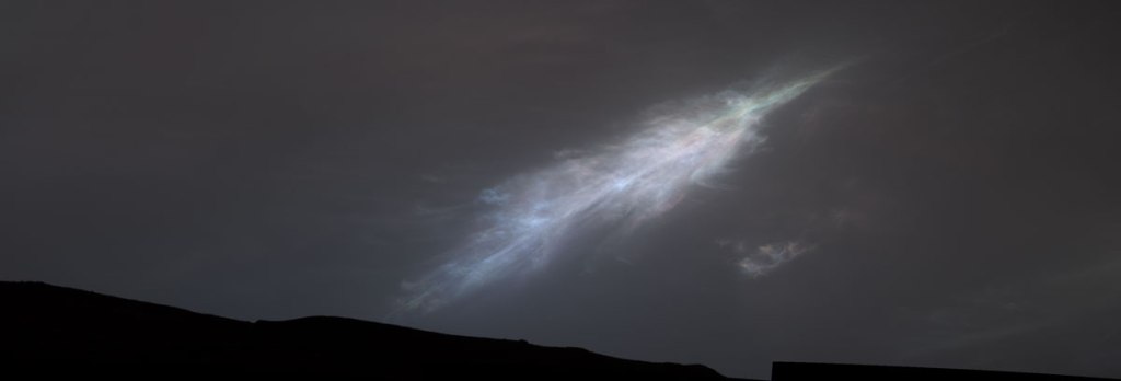
The image in this week’s quiz was taken by NASA’s Curiosity Mars rover and shows a feather-shaped iridescent carbon dioxide cloud shortly after sunset on January 27, 2023.
Here is more from NASA:
Studying the colors in iridescent clouds tells scientists something about particle size within the clouds and how they grow over time. These clouds were captured as part of a follow-on imaging campaign to study noctilucent, or “night-shining” clouds, which started in 2021. While most Martian clouds hover no more than 37 miles (60 kilometers) above the ground and are composed of water ice, these clouds appear to be higher in elevation, where it’s very cold. That suggests these clouds are made of carbon dioxide, or dry ice.
February 8, 2023 Image:
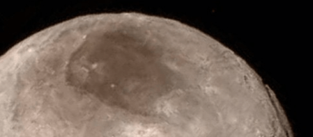
The image in this week’s quiz is a portion of Pluto’s moon Charon. The dark spot in the northern portion is nicknamed “Mordor.”
The entire moon is shown below. Here is NASA’s statement describing what you see:
Remarkable new details of Pluto’s largest moon Charon are revealed in this image from our New Horizons spacecraft taken late on Tuesday from a distance of 289,000 miles (466,000 kilometers). A swath of cliffs and troughs stretches about 600 miles (1,000 kilometers) from left to right, suggesting widespread fracturing of Charon’s crust, likely a result of internal processes. At upper right, along the moon’s curving edge, is a canyon estimated to be 4 to 6 miles (7 to 9 kilometers) deep. Mission scientists are surprised by the apparent lack of craters on Charon. South of the moon’s equator, at the bottom of this image, terrain is lit by the slanting rays of the sun, creating shadows that make it easier to distinguish topography. In Charon’s north polar region, a dark marking nicknamed ‘Mordor’ is prominent in the image. Higher resolution images still to come are expected to shed more light on this enigmatic region.
Note: You were likely to get this quiz right if you had read yesterday’s posted story.

January 9, 2023 Image:
The image in this week’s quiz is that of Jupiter’s second largest moon Callisto. It is also the third largest moon of the solar system, representing a world that is about the size of the planet Mercury. Here are a few more facts from NASA:
- Callisto has a heavily cratered surface of ice and rock;
- NASA’s Galileo spacecraft detected a thin carbon dioxide atmosphere, or exosphere, on Callisto. Later research determined Callisto has hydrogen and oxygen in its atmosphere; and
- There is evidence of a subsurface ocean on Callisto, putting Callisto on the list of possible places where life could exist beyond Earth.

December 24, 2022 Image:

The image above is from Mars. It shows 1 of 10 planned tubes of Martian soil being placed on the surface of Mars by the Perseverance rover. This tube was placed on the surface on December 21. The samples will be returned to Earth at some point in the future as part of the Mars Sample Return campaign. You can read more about it here.

December 12, 2022 Image:

The image in the quiz is that of Neptune’s largest moon Triton. As noted in a Smithsonian National Air & Space Museum story:
The dark streaks in this image are nitrogen geysers erupting at Triton’s south pole. These geysers extend 26,000 ft (8 km) above Triton’s surface, making them 140 times bigger than Yellowstone’s Old Faithful Geyser.
Triton has seasons that last 40 years, but you would not want to be there for any of it’s seasons. Winter is horribly cold while the summer is full of violent geysers.

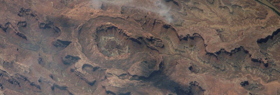
November 7, 2022 Image:

The image above was captured by the International Space Station on August 21, 2022. It is the Richat Structure, also called “Eye of the Sahara,” located in Mauritania. While it may look like an impact crater, it is actually an eroded geological dome.
Below is what could be another eroded geological dome, also photographed by the ISS, but this time in the United States. Called Upheaval Dome, scientists are still discussing whether the crater was created by a salt dome or a meteor.
October 2, 2022 Image:

The image above was taken by European Space Agency astronaut Samatha Cristoforetti aboard International Space Station (ISS). From a height of 260 miles, it shows China’s Tanggula Mountains near Hala Lake. You may have thought it was an image from the surface of Mars. You can find more ISS crew observations here.
September 7, 2022 Image:

The image above shows the China National Space Administration’s (CNSA) Chang’E-5 lander probing the Moon’s surface back in December 2020. The mission returned about 60 ounces of soil and rock samples containing evidence of water from the lunar surface. You can read more about the mission here.

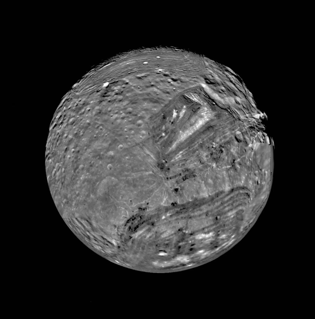
August 15, 2022 Image:
The image above shows the Uranian moon Miranda, taken by the NASA’s Voyager 2 spacecraft on Jan. 24, 1986. It is much smaller than our Moon (only one-seventh the size), though it has canyons that can be about 12 times deeper than those in the Grand Canyon. You can read more about Miranda here.
July 8, 2022 Image:

The image above shows the Shanghai Astronomy Museum, which opened to the public in 2021. The museum architect website notes:
At 420,000 square feet, the new astronomical branch of the Shanghai Science and Technology Museum will be the largest museum worldwide solely dedicated to the study of astronomy.

June 7, 2022 Image:
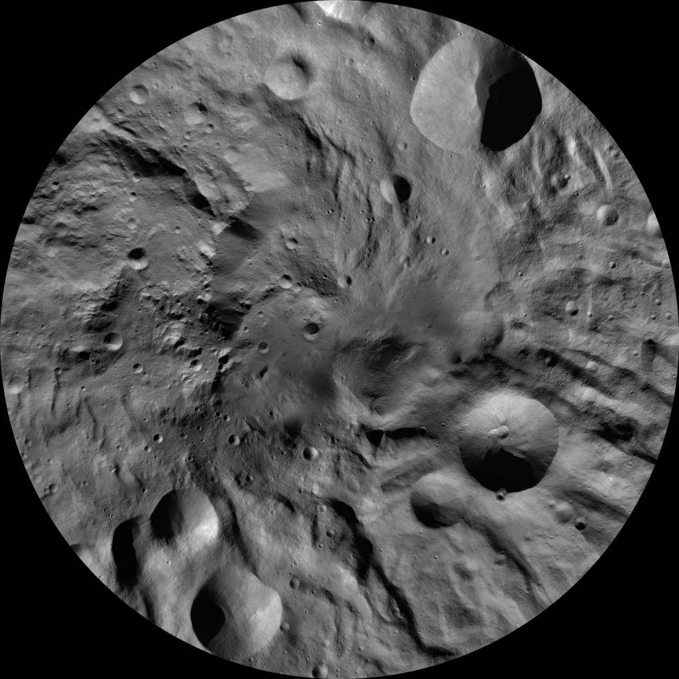
The image above shows the asteroid Vesta and is from NASA’s Dawn mission to both Vesta and the dwarf planet Ceres. The Dawn spacecraft left Earth on September 27, 2007 and started its orbit of Vesta on July 16, 2011. The spacecraft studied the asteroid for 14 months. About 326 miles in diameter, Vesta is believed to be the largest object in the asteroid belt after Ceres.
The image itself is described by NASA in this way:
This image from the atlas of the giant asteroid Vesta was created from images taken as NASA’s Dawn spacecraft flew around the protoplanet. The set of maps was created from mosaics of 10,000 images from Dawn’s framing camera instrument, taken at a low altitude of about 130 miles (210 kilometers).

(NASA/JPL-Caltech/UCLA/MPS/DLR/IDA)
May 3, 2022 Image:

The image above comes from the surface of Mars as captured by the European Space Agency’s (ESA) Mars Express. It shows ice-related features within the Martian Utopia region, which holds the largest known impact basin in the entire Solar System. Here is more from ESA:
Utopia is one of three major basins in Mars’ northern hemisphere (along with Acidalia and Arcadia) and has a diameter of roughly 3 300 km: just under twice the north-south size of Earth’s Sahara Desert.
This image shows a slice of Utopia Planitia, the plain that fills this colossal and ancient basin.
This plain is thought to have formed as the Utopia basin was filled by a mix of sediments, lavas and volatile substances (those that vaporise easily, such as nitrogen, carbon dioxide, hydrogen and water), all transported across the martian surface by water, wind or other processes.
…the two largest impact craters visible here are surrounded by double-layered mounds of material. A similarly layered appearance is also visible in the deposits that have built up within the craters themselves, and in the craters’ thick rims.
April 15, 2022 Image:

The image above from NASA shows collapsed volcanoes that have formed large, dark spots on Io’s surface. Io is Jupiter’s third largest moon. Jupiter’s has 79 moons. NASA noted:
Io is the most volcanically active body in the solar system. Io’s surface is covered by sulfur in different colorful forms. As Io travels in its slightly elliptical orbit, Jupiter’s immense gravity causes “tides” in the solid surface that rise 300 feet (100 meters) high on Io, generating enough heat for volcanic activity and to drive off any water. Io’s volcanoes are driven by hot silicate magma.

March 2, 2022 Image:

The image above is a photo taken by NASA’s Mars rover Curiosity, as NASA explains:
Using an onboard focusing process, the Mars Hand Lens Imager (MAHLI) aboard NASA’s Mars rover Curiosity created this product by merging two to eight images previously taken by the MAHLI, located on the turret at the end of the rover’s robotic arm.
The official Curiosity rover tweet describes the content of the image:
I spy with my hand-held imager (MAHLI) this beautiful, fragile and tiny feature. It’s a concretion, eroded from sedimentary rock that was cemented by mineral-rich groundwater. Size? Just 1 cm.
February 4, 2022 Image:

The strange picture above is a new MeerKAT radio telescope image of the center of the Milky Way Galaxy. Here is the story:
The image captures radio emission from numerous phenomena, including outbursting stars, stellar nurseries, and the chaotic region around the 4 million solar mass supermassive black hole that lurks in the centre of our Galaxy, 25,000 light-years from Earth. Radio waves penetrate the intervening dust that obscures the view of this region at other wavelengths. MeerKAT’s innovative design, sensitivity, and geographical vantage point have been the keys to producing the remarkable image, which reveals new supernova remnants – the expanding shells of material left behind when massive stars end their lives explosively – including a rare almost-perfect spherical example, and provides astronomers with the best insight yet into the population of mysterious ‘radio filaments’ found nowhere else.
Here is the full press release from the South African Radio Astronomy Observatory (SARAO) discussing various aspects of this image.
January 17, 2022 Image:

The image above is the Hunga-Tonga-Hunga-Ha’apai volcanic eruption from late last week. According to NASA, the eruption in the Pacific Ocean caused quite a stir throughout the world:
On January 14, the Volcanic Ash Advisory Center Wellington (VAAC) reported a very large eruption at Hunga Tonga-Hunga Ha’pai, based on satellite imagery. At that time, the steam obscured the ash plume and the height of the ash plume was unknown. According to the Global Alert and Disaster Coordination System (GDACS), a 5.8 magnitude earthquake was registered from Tonga on that day, at a depth of 5 km, with 800,000 people within 100 km of the quake.
By the morning of January 15, GDACS recorded a second large earthquake (4.5 magnitude) and the volcano exploded in a “major vent-clearing event”, according to a report from ABC NEWS in Australia. The eruption was heard in New Zealand, 1,300 miles away, and Alaska, which sits roughly 6,000 miles away. The powerful explosion—made even stronger by sizzling hot magma reacting with cold ocean water—triggered a tsunami. Waves washed over nearby islands, knocking down communication lines, flooding coastlines, and forcing evacuations from low-lying areas. Australia offered to send reconnaissance flights over Tonga’s islands to assess damage, but as of late on January 15, the thick plume of ash prevented such flights from occurring.
Tsunami waves coursed across the vast Pacific Ocean, bringing surges of more than 3 feet to Alaska, coastal flooding in California, and smaller surges in Oregon, Washington State, British Columbia, Mexico, South America, Hawaii, and Japan. By the late evening of January 15, tsunami warnings had been downgraded or cancelled along most of the Pacific basin. Some speculate that the January 15 eruption was among the strongest in the 21st century—a theory that will be tested as scientists sort through data and damage estimates over the next few weeks or months.
Of course, volcanoes can be found throughout the solar system, including on Mars, Venus, and the moons of Jupiter and Saturn. Dwarf planets, including Pluto and Ceres, are also believed to have volcanoes. The image below is an apparent ice volcano on Ceres called Ahuna Mons. The image is from NASA’s Dawn spacecraft taken in December 2015 about 240 miles above the surface.

